What does archaeology tell us about Paul’s travels through Cyprus (Acts 13:4-12)?
Introduction
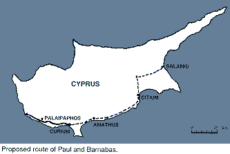
Paul and Barnabas arrived at Salamis on Cyprus by sea and preceded “through the whole island as far as Paphos” (Acts 13:6). On other parts of their travels it seems likely that they took advantage of the network of roads constructed under the authority of Rome. Thus after leaving Cyprus on their way to Psidian Antioch, Paul used the via Sebaste constructed in 6 BC by Augustus.[1] In Macedonia the via Egnatia served as the route from Neapolis westwards.[2]
The Cyprus journey would have taken the pair of them from the east coast of Cyprus to the west. This claim may reflect the way that the route used passed through some of the most important cities of the island. However, it is first important to understand the development of the province.
The province was acquired in 58 BC (Badian 1965), although Cyprus had earlier been considered as one of the “friends and allies of Rome.”[3] Initially it formed an annex to the Roman province of Cilicia,[4] and in 48/7 BC the island was returned to the control of Egypt. The death of Cleopatra in 31 BC brought Cyprus back under Roman control. Subsequently, in 22 BC, Augustus made Cyprus one of the senatorial provinces under a proconsul of praetorian status. There were no Roman colonies established on the island.
The roads of Roman Cyprus

The evidence for a road between Salamis and Paphos is twofold: firstly in the form of the Roman itineraries, and secondly in the form of milestones. The “Peutinger Table” which lists the routes and mileages would suggest two possible routes from Salamis (Miller 1916: 827-29). The first cut to the north-west to Chytri, over the Kyrenia Ridge to the north coast. It then followed the coast to Soli, Arsinoe (Marion), and then south to Paphos. The second headed for Citium on the south coast, then westwards to Amathus, Curium and then Paphos. These routes are not contemporary, and are likely to have developed over a period of time. The distances can be tabulated as follows:
| Salamis to Tremithus | 18 miles |
| Tremithus to Citium | 24 miles |
| Citium to Amathus | 24 miles |
| Amathus to Curium | 16 miles |
| Curium to Palaipaphos | 22 miles |
| Palaipaphos to Paphos | 11 miles |
| Total | 115 miles |
This gives a total of 115 miles.[5] The alternate route via the north coast would have been much longer. 88 miles from Salamis to Soli (or 71 miles via Tremithus), and then another 54 miles to Paphos via Arsinoe, giving a total of 142 miles.[6] The distances between cities would also be convenient for a day’s travel, making this at least a six day journey from one end of the island to the other.[7]
The best way of dating these roads is by the surviving milestones which often bear the names of the emperor (Mitford 1980: 1333-35, n. 213). Most of these belong to the fourth century AD, and are likely to represent a period of repair to the road system rather than its expansion. Paul’s and Barnabas’ journey, at least along the south coast, would have been facilitated by the construction of a Roman road during Augustus’ reign. This is attested by a milestone, located 11 (Roman) miles from Paphos towards Curium (Mitford 1966:98-99 no. 3).[8] It reads:
[imp.ca]ESAR AVG[vstvs]
[divif.]PONTIF[ex max.]
[trib.potest.-cos.-]
As Augustus is named as pontifex maximus the work must have taken place after 12 BC.[9] Although the inscription only allows certainty about the construction of the road between Paphos and Curium, it is possible that it was extended eastwards as far as Salamis. The next significant development was the construction of “new roads” ([via]s novas; Corpus inscriptionum latinarum III.6732)10] throughout the province[11] between July and September 81 during the reign of Titus.[12] A milestone identified a new road heading north-east from Salamis to Agios Theodoros and thence presumably to Carpasia.[13] The other roads which were constructed in the Flavian period were presumably an extension to the Augustan scheme. Mitford proposed that the route across the heart of Cyprus from Soli to Salamis was one of these constructions (1980: 1336).
The next main series of inscriptions comes from the Severan period.[14] As some of these were found along the road heading from Paphos to Curium it is clear that this was in part repair work. However, it is from this period that there is the first clear indication of a road from Soli to Arsinoe and then south to Paphos.[15] Given this evidence the simplest solution to the proposed route of Paul and Barnabas was from Salamis along the south coast.
Cities visited by Paul and Barnabas
The only cities on Cyprus mentioned in the Book of Acts are Salamis and Paphos. However, if Paul and Barnabas travelled on foot along the Augustan road along the south coast,[16] they would have passed through Citium, Amathus and Curium before reaching Paphos.[17]
Three of the cities had been granted the status of asylum in AD 22 due to the standing of their civic sanctuaries.[18] These were Salamis (Olympian Zeus; Mitford 1990: 2189-90), Amathus (Aphrodite; Mitford 1990: 2185), and Paphos (Paphian Aphrodite). It should be noted that although these deities may sound like anthropomorphic Olympian gods, in fact, some had a more regional feel. Paphian Aphrodite was in fact represented by a sacred rock or baetyl, rather than the cult statue of a goddess.[19]
A similar cult of sacred rocks is recorded near Amathus. An inscription found at Agios Tychon near Amathus records a cult of “Cyprian Aphrodite” and the sanctuary of “the Seven within the Stelai” (Mitford 1980: 1302, no. 28; 1946: 40-42, no. 16).[20] The dedication was made by the Roman governor of Cyprus, L. Bruttius Maximus (79/80). This was presumably a sanctuary with a central baetyl with other sacred rocks around it. The worship of sacred rocks is not uncommon in the east. In particular, the famous baetyl of Emaesa was to be taken to Rome by Elagabalus[21] or the cult of Artemis at Perge (Butcher 1988: 90, fig. 6.114).
The sanctuary of Paphian Aphrodite also came to be linked to the imperial cult. The imperial cult was linked to the sanctuary of Aphrodite at Palaipaphos. For example Livia was identified as the new Aphrodite (Gardner, Hogarth and James 1888: 242, no. 61), and Augustus’ daughter Julia as Augusta (Inscriptiones Graecae ad Res Romanas Pertinentes III.940). Other inscriptions relating to the imperial cult include and honorific inscription for Amyntor son Lysias, “high priest for life for the well-being of the imperial household” (Mitford 1990: 2197).
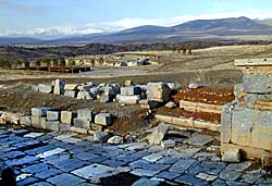
Both Salamis and Paphos were the two most important cities on the island. Paphos was the seat of the provincial administration (Mitford 1980: 1309-15), and it was here that Paul met the governor of the island, Sergius Paulus.[22] It had been founded around 312 BC, to replace Palaipaphos. During the second century BC it seems to have become the leading city of the island, taking the prominence away from Salamis.[23]
The city had been wrecked by an earthquake in 15 BC and Augustus had subsequently conferred on the city the title Augusta (Mitford 1980: 1310, with details of the proper title). Further honors were given to the city, perhaps under Nero, when it received the extra title of Claudia (Mitford 1980: 1310).[24]
Paphos’ centrality in the Roman scheme of affairs is also emphasized by the milestones that mark distances from it. Of the other cities Citium managed to retain elements of its earlier Phoenician past (Mitford 1980: 1318-20). The earlier Phoenician cult of Eshmun became that of Asclepius which was active under Augustus (Mitford 1980:1319). One of the first century BC or Augustan high-priests and benefactors of the cult carried a name, Asclepiodorus son of Asclepiodorus, which reveals his links with Asclepius.[25]
Elsewhere in the city a stoa was dedicated in 41 BC to Zeus Keraunios, to the Divine Julius and to Aphrodite (Corpus Inscriptionum Graecarum 2641; Mitford 1990: 2195). Amathus also had an important cult site of Hera, which was certainly active in the Claudian period (Inscriptiones Graecae ad Res Romanas Pertinentes III.974).[26]
An altar dedicated to Augustus was found on the acropolis (Inscriptiones Graecae ad Res Romanas Pertinentes III.973). The sanctuary of Apollo Hylates, which lay just to the west of the city, may have been developed at the same time.
In conclusion, the route followed by Paul and Barnabas through Cyprus would have brought them to several of the key cities of the island, including the three which had been granted the special status of asylum. The itinerary suggests that this would have taken at least a week. The road would have brought them into contact with some of the main cult centers such as the sanctuary of Aphrodite at Palaipapos. It also led them to the heart of the Roman administration of the island at Paphos.
More information online
- Paul, the apostle
- Cyprus
- Chittim
- Paphos
- Salamis
- Barnabas
- islands of the Bible
- Rome
- Biblical weights and measures
- Bible archaeology
Footnotes
- For example: French 1994: 49-58; see also Mitchell 1993: 70. For further information on the Anatolian road system: French 1980:698-729; 1988.
- Gill 1994: 409-10. Paul’s visit to Illyricum (Rom 15:19) may have used this route (Gill 1994: 410).
- The Roman piracy laws of 101 or 100 BC reflect this status for Cyprus. For a translation of the texts, see Sherk 1984, no. 55 (Delphi B, and Knidos).
- Cicero was one of the republican governors of the island, but did not apparently land there, controlling it from Cilicia. For a list of governors, see Mitford 1980: 1292. The first quaestor for the island was not appointed until 49 BC.
- These are Roman miles.
- These itineraries do appear to be on the short side when compared to the distances marked by the milestones. For example, there must be more than 32 miles between Paphos and Curium (24 miles marked from Paphos, and 8 miles marked from Curium), and more than 24 miles from Arsinoe to Paphos (15 miles marked from Arsinoe, and 9 from Paphos) on a length that is recorded as 24 miles long.
- Rapske (1994: 6) uses the estimate of 16-23 miles per day. The journey may have been longer if Paul and Barnabas stayed in any one of the cities along the way. Luke’s emphasis may imply that it was a straight journey with no stops longer than an evening.
- The milestone is now in the Kouklia museum.
- Compare the date of 6 BC for the Via Sebaste which linked the Roman colonies of southern Anatolia. See French 1980: 707, 708, map 2. The milestones dating to 6 BC may be found in French 1988, nos. 267, 292, 293, 298, 391, 395, 498, 636, 663, 664, and 670.
- This was during the governorship of L. Plotius P---- (Mitford 1980: 1302, no. 29). See also Mitford 1939: 188-89.
- A second milestone (Mitford 1980: 1335, no. 25) without recorded provenance reads [ted eparche]iad.
- Compare the development of the road system in Anatolia between AD 80 and 82 (Mitchell 1993: 124). The milestones of A. Caesennius Gallus “state explicitly that he laid roads in the provinces of Galatia, Cappadocia, Pontus, Pisidia, Paphlagonia, Lycaonia, and Armenia Minor” (Mitchell 1993: 124). These are conveniently listed in French 1988: 507-508. French (1980: 711) takes the words via straverunt (or stravit) in Anatolia to imply that these were paved roads replacing earlier tracks.
- We should note that this coincides with Flavian road building in Cilicia opposite Carpasia (French 1988: 710, map 3, 712, map 4). The key milestone comes from Ura and dates to AD 75-76 (Vespasian) (French 1988: 163-64, no. 461).
- Milestones from this period also dominate in the archaeological record of Anatolia: French 1980: diagram 7, opp. p. 720, where 68 examples are noted. For a list: French 1988: 438-42.
- I reject Mitford’s suggestion that “the circuit of Cyprus … was surely devised as a single operation” (1980: 1335, n. 216). Compare the development of the road system in Asia Minor, which emphasizes the administrative centers: French 1980: 706, map 1, 707. I am grateful to Prof. Stephen Mitchell for drawing my attention to the weakness of Mitford’s argument.
- Land, rather than sea, travel is implied by “through the whole of the island.”
- Tremithus is a further possibility depending on the route from Salamis to Citium. For the cities of Cyprus, see Jones 1971: 363-73.
- For the asylum decree: Tacitus Annals 3.62.
- A representation of the baetyl within the sanctuary can be found on the coinage of Paphos: Butcher 1988: 59, pl. 5, nos. 53 and 54.
- The inscription can be dated to 1 July-22 September 80.
- For a convenient discussion of the cult see Millar 1993: 304-308. See also Butcher 1988: 56, fig. 5.68.
- For the most recent discussion, see Nobbs 1994:282-89.
- For details of Salamis: Mitford 1980: 1321-23. The temple of Zeus Olympius adjoined the main agora of the city. Augustus was honored by the provincial high-priest Hyllos son of Hyllos in 12/11 BC (Mitford 1990: 2196).
- This may have been linked to the establishment of games at Paphos in Nero’s honor.
- The inscription honors Pnytarion; see Mitford 1961: 113-16, no. 15. Asclepiodorus, her husband, was second founder and high priest of the cult of Asclepius and Hygieia.
- The inscription is dated to AD 50, see Mitford 1990: 2185. For details of Amathus, see Mitford 1980: 1315-17.
References
- Badian, E. 1965 M. Porcius Cato and the Annexation and Early Administration of Cyprus. Journal of Roman Studies 55:110-21.
- Butcher, K. 1988 Roman Provincial Coins: An Introduction to the “Greek Imperials.” London: Seaby.
- French, D.H. 1980 “The Roman Road System of Asia Minor”. Pp. 698-729 in Aufstieg und Niedergang der r’mischen Welt II.7.2, eds. H. Temporini and W. Haase. Berlin.
- 1988 “Roman Roads and Milestones of Asia Minor”, fasc. 2: An Interim Catalogue of Milestones, British Archaeological Reports International Series 392, British Institute of Archaeology at Ankara monograph 9. Oxford: BAR.
- 1994 Acts and the Roman Roads of Asia Minor. Pp. 49-58 in The Book of Acts in its Graeco-Roman Setting, The Book of Acts in its First Century Setting 2, eds. D.W.J. Gill and C. Gemp. Grand Rapids: Eerdmans.
- Gardner, E.A.; Hogarth, D.G.; and James, M.R. 1888 “Inscriptions of Kuklia and Amargetti.” Journal of Hellenic Studies 9.
- Gill, D.W.J. 1994 Macedonia. In The Book of Acts in its Graeco-Roman Setting, The Book of Acts in its First Century Setting 2, eds. D.W.J. Gill and C. Gemp. Grand Rapids: Eerdmans.
- Jones, A.H.M. 1971 The Cities of the Eastern Roman Empire (2nd ed.). Oxford: Clarendon Press.
- Millar, F. 1993 The Roman Near East 31 BC-AD 337. Cambridge MA: Harvard University Press.
- Miller, K. [1916] 1964 Itineraria Romana. Reprint. Rome: L’Erma di Bretschneider.
- Mitchell, S. 1993 Anatolia: Land, Men and Gods in Asia Minor 1: The Celts and Impact of Roman Rule. Oxford: Clarendon Press.
- Mitford, T.B. 1939 “Milestones in Western Cyprus”. Journal of Roman Studies 29.
1946 “Religious Documents from Roman Cyprus”. Journal of Hellenic Studies 66.
1961 “Further Contributions to the Epigraphy of Cyprus”. American Journal of Archaeology 65.
1966 “Three Milestones of Western Cyprus”. American Journal of Archaeology 70.
1980 “Roman Cyprus”. Aufstieg und Niedergang der r’mischen Welt II.7.2, eds. H. Temporini and W. Haase. Berlin.
1990 “The Cults of Roman Cyprus”. Aufstieg und Niedergang der rimischen Welt II.18.3, eds. H. Temporini and W. Haase.Berlin.
- Nobbs, A. 1994 Cyprus. In The Book of Acts in its Graeco-Roman Setting, The Book of Acts in its First Century Setting 2, eds. D.W.J. Gill and C. Gemp. Grand Rapids: Eerdmans.
- Rapske, B. 1994 “Acts, Travel and Shipwreck”. In The Book of Acts in its Graeco-Roman Setting, The Book of Acts in its First Century Setting 2, eds. D.W.J. Gill and C. Gemp. Grand Rapids: Eerdmans.
- Sherk, R.K. 1984 Rome and the Greek East to the Death of Augustus. Cambridge: CUP.
Author: David W.J. Gill as excerpted from the Tyndale Bulletin 46.2 (1995): 219-228. Supplied by Associates for Biblical Research
Copyright © 1995, David W.J. Gill, All Rights Reserved—except as noted on attached “Usage and Copyright” page that grants ChristianAnswers.Net users generous rights for putting this page to work in their homes, personal witnessing, churches and schools.